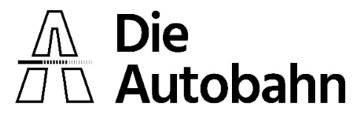
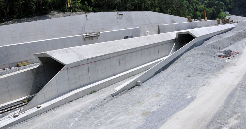
Railway Infrastructure Works Lake Zug East, Switzerland, Office: Emch+Berger WSB AG; ©ALLPLAN Schweiz AG
Road and Infrastructure
FOR INFRASTRUCTURE DESIGNERS WHO DEMAND MORE.
ALLPLAN’s BIM solutions for road and infrastructure design cover the entire design to build process. ALLPLAN enables the seamless integration with other civil engineering discipline design requirements – including bridges – with collaborative workflows that support greater productivity for project design and delivery. Expect more from your road and rail infrastructure planning software!
Railway Infrastructure Works Lake Zug East, Switzerland, Office: Emch+Berger WSB AG; ©ALLPLAN Schweiz AG
ALLPLAN – BIM SOLUTIONS
FOR INFRASTRUCTURE DESIGN
From construction site access, to roads leading up to bridges or through tunnels, to highways incorporating retaining walls, junctions and overpass viaducts, or designing interactions between tracks and newly built station buildings, effective and integrated design for road and rail infrastructure elements, requires knowledge, experience, and precision tools.
With ALLPLAN, you can easily incorporate digital site terrain models, swiftly import alignments, parametrically model roads, and utilities, and even add construction equipment to plan and optimize the site layout design. This is enhanced with advanced parametric bridge design tools and capabilities for modeling tunnels. These integrated solutions are combined with effortless collaboration functionality and powerful tools to quickly detail variants, efficiently manage changes, and swiftly generate accurate site and construction deliverables to ensure projects are realized more successfully
12 REASONS TO CHOOSE ALLPLAN
ALLPLAN workflows for Road and Infrastructure Design
Skip
- 1 \ Site Analysis Terrain Survey
- Geodata Processing (SHP)
- Data Exchange
- 2 \ Modeling Parametric Modeling
- Free-form Modeling
- Visualisation
- 3 \ Model Analysis Variant Comparison
- Change Management
- 4 \ Deliverables Drawings: Cross section, Longitudinal section and Site plan
- Reports
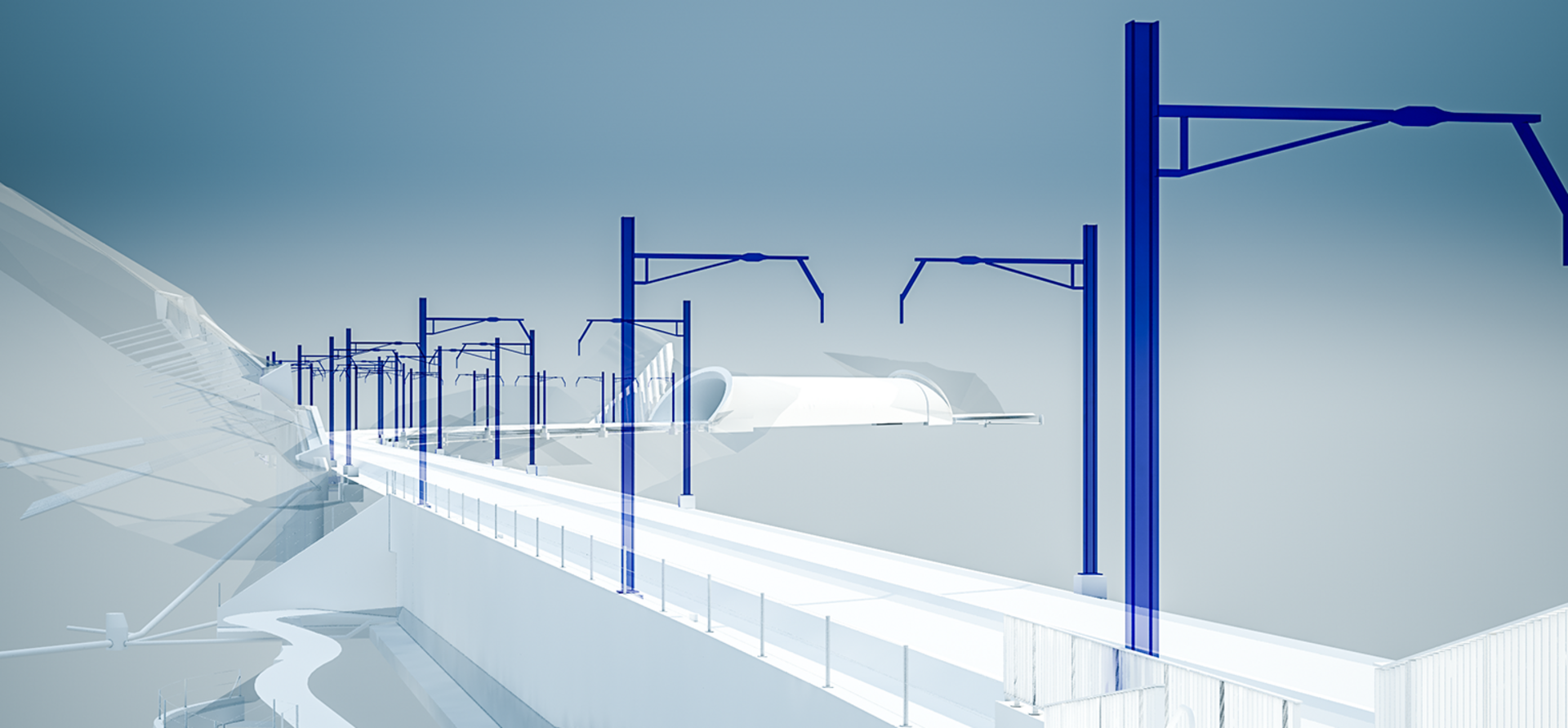
Terrain data can be read in the form of large point clouds (for example from Scalypso) and displayed graphically. This makes it possible to use high-resolution terrain models as the basis for mass determinations within infrastructure projects.
[...read more]Terrain data can be read in the form of large point clouds (for example from Scalypso) and displayed graphically. This makes it possible to use high-resolution terrain models as the basis for mass determinations within infrastructure projects.
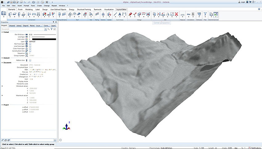
The processing of geodata enables the recording of property boundaries, flood plains, road networks and much more. With this information, critical zones or points of conflict can be recognised at an early stage and taken into account in project planning. The imported geo-information can also be considered when creating output plans.
[...read more]The processing of geodata enables the recording of property boundaries, flood plains, road networks and much more. With this information, critical zones or points of conflict can be recognised at an early stage and taken into account in project planning. The imported geo-information can also be considered when creating output plans.
For the interdisciplinary exchange of project information, the elements of a road model can be provided with attributes and subdivided into logical road sections. For this purpose, the specifications of the open standard IFC 4.3 from BuildingSmart were implemented for object structuring. By defining attributes, the model can be enriched with essential project and product information. This information can then be made available to all project participants via cloud services.
[...read more]For the interdisciplinary exchange of project information, the elements of a road model can be provided with attributes and subdivided into logical road sections. For this purpose, the specifications of the open standard IFC 4.3 from BuildingSmart were implemented for object structuring. By defining attributes, the model can be enriched with essential project and product information. This information can then be made available to all project participants via cloud services.
No project is immune to adapted framework conditions or unforeseeable project changes. With the help of the consistent parametric modelling concept, geometric adaptations can be made at any time and the model updated according to the changed initial conditions. The effort required to adapt the geometric model is minimal and changes are made possible in short time frames.
[...read more]No project is immune to adapted framework conditions or unforeseeable project changes. With the help of the consistent parametric modelling concept, geometric adaptations can be made at any time and the model updated according to the changed initial conditions. The effort required to adapt the geometric model is minimal and changes are made possible in short time frames.
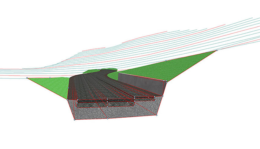
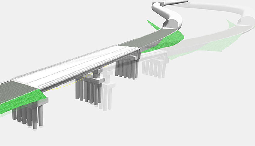
In ALLPLAN it is easy to extrude freely defined profiles along a line element. This allows, for example, railroad tracks, road dividers, guard rails, support elements, etc. to be placed relative to the axis and consequently also taken into account in the output plans.
[...read more]In ALLPLAN it is easy to extrude freely defined profiles along a line element. This allows, for example, railroad tracks, road dividers, guard rails, support elements, etc. to be placed relative to the axis and consequently also taken into account in the output plans.
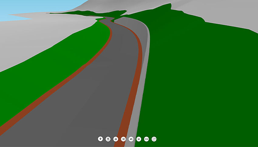
Visualisation facilitates cooperation and communication between the project participants. All disciplines can analyse the model together for details, improvements, etc. The visual representation of the road facilitates feedback. Thanks to the excellent visualisation quality within ALLPLAN, structural features can be checked in real time and discrepancies can be resolved quickly.
[...read more]Visualisation facilitates cooperation and communication between the project participants. All disciplines can analyse the model together for details, improvements, etc. The visual representation of the road facilitates feedback. Thanks to the excellent visualisation quality within ALLPLAN, structural features can be checked in real time and discrepancies can be resolved quickly.
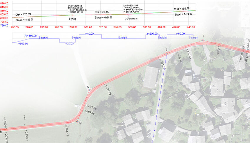
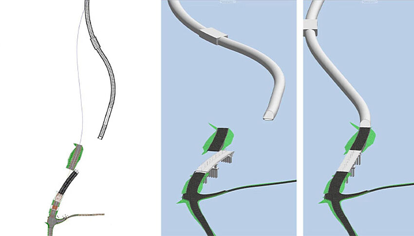
Creating multiple road axes for optimal line routing is achieved effortlessly. Once an axis has been defined, a rule profile can be assigned to it. The differences between different alignment variants can be quickly recorded and easily compared with each other.
[...read more]Creating multiple road axes for optimal line routing is achieved effortlessly. Once an axis has been defined, a rule profile can be assigned to it. The differences between different alignment variants can be quickly recorded and easily compared with each other.
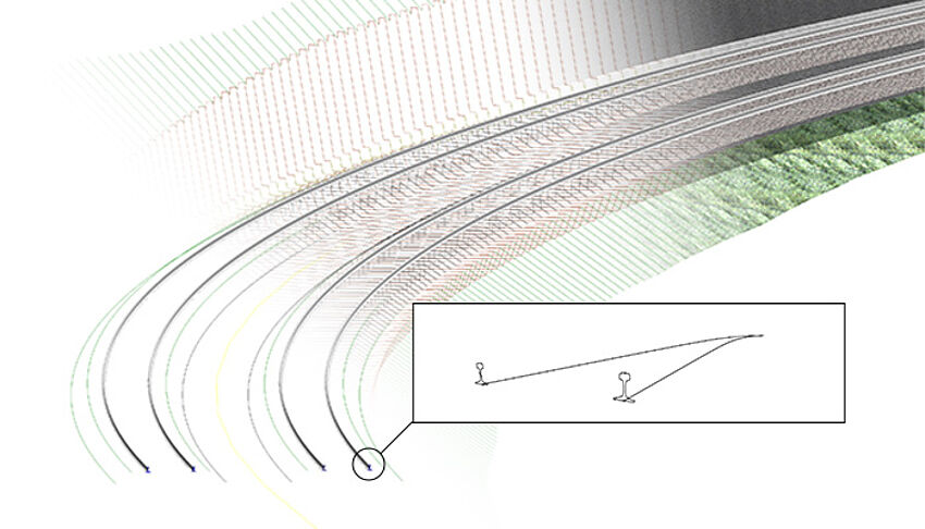
The project area is often surveyed during the execution phase - for example by means of drone flights - and directly compared with the model. Any deviations between the model and the construction situation on site can be quickly detected, validated and, if necessary, adjusted accordingly.
[...read more]The project area is often surveyed during the execution phase - for example by means of drone flights - and directly compared with the model. Any deviations between the model and the construction situation on site can be quickly detected, validated and, if necessary, adjusted accordingly.
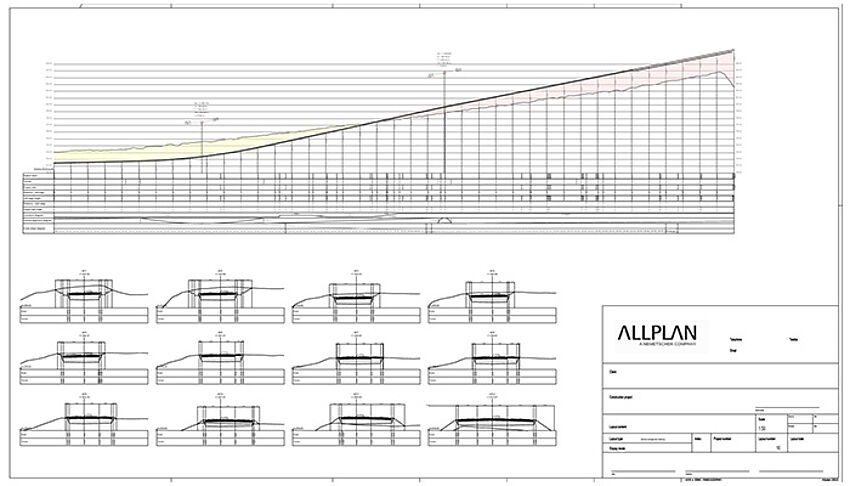
The creation of output drawings is fully automated and always reflects the current model. Depending on requirements, the plan contents can be expanded and adapted as desired.
[...read more]The creation of output drawings is fully automated and always reflects the current model. Depending on requirements, the plan contents can be expanded and adapted as desired.
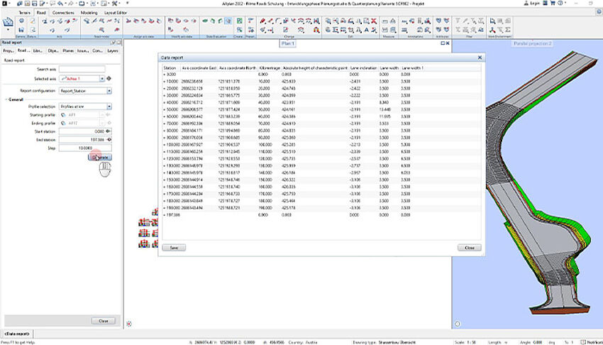
With the help of reports, parameters of the road model can be output in tabular form. For example, staking points can be created, point distances calculated or bulk and fill volumes determined. The calculation accuracy is freely selectable, and the results can be easily transferred to corresponding programmes for data processing.
[...read more]With the help of reports, parameters of the road model can be output in tabular form. For example, staking points can be created, point distances calculated or bulk and fill volumes determined. The calculation accuracy is freely selectable, and the results can be easily transferred to corresponding programmes for data processing.
Choose Workflow phase
Our Offering
Bim Software
for the AEC Industry
ALLPLAN’s BIM solutions for road, rail and infrastructure design cover the entire design to build process, taking collaborative workflows to new levels and enabling more precision and greater productivity in the realization of your projects. Expect more from your infrastructure software.
About
ALLPLAN
"Let me show you a seamless workflow between architecture and structural design!"
- Maximilian Amandi
- Presales Engineer, ALLPLAN
About
ALLPLAN
"ACS-Partner AG share their experiences with deploying BIM2Field."
- Siro Boitier
- Civil Engineer, ACS-Partner AG

About
ALLPLAN
"Welcome the automation of infrastructure projects. Let me show you how!"
- Zeljka Devedzic
- Teamlead SE & Consulting Infrastructure ALLPLAN
About
ALLPLAN
"Take your steel detailing projects to the highest level with SDS2 by ALLPLAN!"
- David Zabka
- Product Manager, ALLPLAN
Success Stories
CUSTOMER PROJECTS DESIGNED AND BUILT WITH ALLPLAN
Gotthard Base Tunnel
Switzerland
The scheduled commissioning on December 11, 2016, marked the end of the project of the century – the Gotthard Base Tunnel – after nearly 20 years of building time. Its route length of 57 kilometers through the Saint-Gotthard Massif between Erstfeld and Bodio makes the Gotthard Base Tunnel the longest rail tunnel in the world.
A2 Freeway
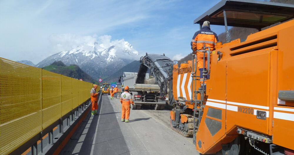
Stansstad-Beckenried, Switzerland
The project placed high demands on the accuracy of the installation of the new road surface. The repair work must be carried out within a short space of time, among traffic, and in very tight spaces on site. To meet these demands, the repair work on the Stansstad section to freeway exit Stans Süd, including the preferred measures, has been divided into six phases.
Four-track extension
Switzerland
The four-track extension of the Olten-Aarau route has relieved one of the most severe bottlenecks on the east-west axis of the Swiss rail network. The project, costing CHF 855 million, includes expansions in the east of Olten, a fourth 2.5-kilometer-long track between Dulliken and Däniken and – as the core element – the double-track, three-kilometer-long Eppenberg Tunnel and comprehensive measures for its connection.
WELL-KNOWN COMPANIES WHO TRUST ALLPLAN: